Low Snowpack Leading to an Early and Very Low Peak Runoff for Roaring Fork River
The central mountains of Colorado, including Aspen, are currently experiencing a snowpack that is only 42% of the seasonal average, a dramatic shortfall that is already producing consequences for river flows, drought conditions, and fire risk across the region.
Meteorologist Kris Sanders with the National Weather Service in Grand Junction confirmed the snowpack is not only low, but melting rapidly.
“We peaked at pretty close to normal — around 80% — but normally we see the snowpack last a little longer,” he said. “It has been melting quicker.”
The zero snow water equivalent, a measurement of the amount of water contained in snowpack, is projected by the end of May, Sanders said. In other words, there soon won’t be any water content left in the central mountains’ snowpack.
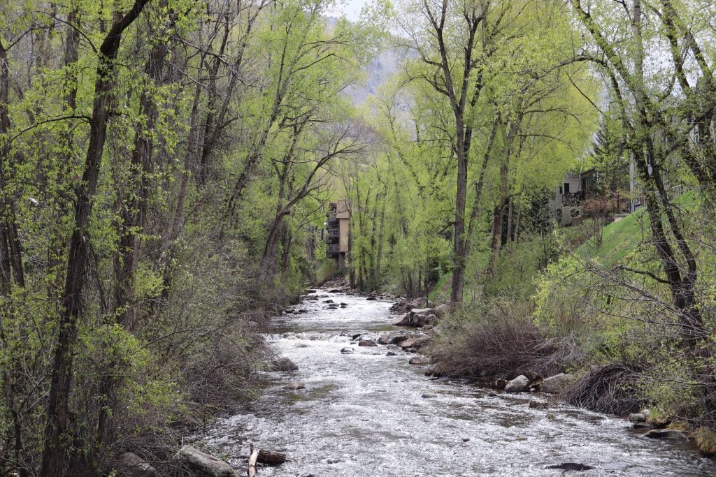
“The peak flow for the Roaring Fork River is expected by the end of the month, which means essentially everything will be melted off,” Sanders said. “What the river has been maintaining currently is essentially our peak runoff. We are at a plateau, but there could be a little increase.”
Sanders noted that recent precipitation will offer only short-term relief. He said the Roaring Fork Valley received up to less than one inch of rain, and four to eight inches of snow in the higher elevations, with close to a foot at the highest.
“It may make a day or two difference with maintaining the snowpack, but that is about it,” he said.
He added that the central mountains are forecasted to remain abnormally dry, with moderate drought conditions likely persisting through the summer.
“The further west you go on the I-70 corridor, the more severe or extreme drought conditions we are expecting.”
Matthew Anderson, water quality program manager with the Roaring Fork Conservancy, confirmed that snowpack levels have dropped significantly since early April.
“Those snowpack conditions corroborate with what we are seeing. That 42% is less than half of what would be average,” he said. “If you think of this as a letter grade, 42% is quite poor. We have been seeing this snowpack disappear right in front of our eyes.”
Anderson explained that cooler weather recently slowed river runoff, but that warmer temperatures expected later this week will trigger additional flows.
“River flows will come up by the end of this week, but the peak will be both early and much lower than average,” he said.
He pointed to current Roaring Fork River flows at Glenwood Springs, which are around 900 cubic feet per second (cfs) due to recent cold. The Colorado Basin River Forecast Center expects peak flows to reach 2,000 cfs within 10 days, a steep drop from the usual 6,000 cfs typically seen in early June.
This accelerated and diminished runoff has critical implications.
“We will be looking at water temperatures in the rivers. There is a threshold where we start to see aquatic life negatively impacted,” Anderson said. “Aquatic life is incredibly resilient, but we find that around 68 degrees Fahrenheit is where trout start seeing those negative impacts.”
If stream temperatures rise to that threshold, Colorado Parks and Wildlife may impose fishing restrictions.
Anderson added that low snowpack in the Arkansas and South Platte river basins could further impact the Roaring Fork Valley through increased water diversions.
“The implications for us on our side of the divide for those other river flows are that we could see increased water diversions that run through the tunnels into Twin and Turquoise Lakes,” he said. “We will definitely be keeping our eyes on that for sure.”
In terms of fire risk, Anderson warned that drought conditions increase vulnerability across the landscape.
“When you have less water in the rivers, you are also going to typically see less water in the soil and vegetation,” he said. “So that means that not only are those drier soils and vegetation going to be more susceptible to fire, but when it does rain, those areas are going to suck the water up right away. It’s a game of deficits, right? How much water can we get in the form of rain?”
While recent rain has helped momentarily hydrate soils and boost streamflow, Anderson cautioned that those benefits are fleeting, lasting only a few days under dry conditions.
Sanders noted that the highest fire danger this season is forecasted further south, especially in the San Juan Mountains.
“It has been such a low snow year down in the San Juans. At least Aspen saw around 80% of its total snowpack, but the San Juans saw only 50% of their peak,” he said. “I do not see anything too concerning for the Aspen area as far as increased fire risk, but things can change once the weather heats up in June.”
A return of the summer monsoon in July could help mitigate fire conditions, Sanders added, though the timing and strength of that system remain uncertain.
Jake Andersen, deputy chief of operations for the Aspen Fire Protection District, echoed the concerns about diminished snowpack.
“The snowpack totals are concerning. It’s important to note that small bouts of moisture, like we just experienced, are helpful in the short term, but they are substantially less impactful than the state of our snowpack,” he said. “We are starting in a worse place than we have in recent memory, but I am hoping for more moisture and that our communities will continue to be proactive in using the time that we have to get better prepared.”
By: Westley CrouchI The Aspen Times I May 20, 2025